Bringing the Harakbut Face to the World — Without Bringing the World to It

Michael Rubloff

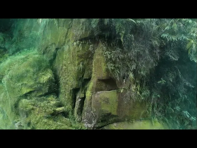
Deep in the Peruvian Amazon, where the Amarakaeri Reserve protects one of the most biodiverse and culturally rich regions on Earth, stands a monumental rock formation known as the Harakbut Face. Sacred to the Indigenous Harakbut people, this site embodies ancestral memory and spiritual connection to the land. Yet, as extractive pressures continue to threaten its surroundings, a new kind of preservation effort has emerged, one rooted not in excavation, but in reconstruction.
In this conversation, we speak with the reality capture specialist behind the Harakbut Face digital twin, whose work bridges technology and tradition. Through respectful collaboration with local leaders and the careful use of Gaussian Splatting, the project reimagines how sacred heritage can be experienced, studied, and protected in the digital age. Please enjoy the conversation!
How did you first get involved with the Harakbut Face preservation project, and what drew you to it personally?
The project began under the initiative of SPDA and ECA Amarakaeri, who had already been working together for several years to protect the reserve where this sacred formation is located. They were looking for new ways to tell its story and preserve its cultural meaning through technology. The idea was to bring the Harakbut Face to people, instead of bringing people to the site.
During that process, the communications team at SPDA contacted the Henry Barrett agency, and they suggested speaking with DCMS Network, where I was working at the time on reality-capture projects. That is how the project reached me.
I had already heard about the Harakbut Face and its cultural significance. Being able to visit and document it was a privilege, especially because access is strictly limited to research and conservation. I was drawn by everything this mission represented, and by the possibility of applying new reality-capture tools to such an important cultural and spiritual place.
What were some of the initial conversations like between the indigenous community and your technical team? How did you ensure mutual understanding and respect?
SPDA and ECA Amarakaeri spent almost a year coordinating access with both the technical team and the Indigenous community. Those conversations were essential to define how to document the site without disturbing the environment or going against cultural values. With that guidance, we developed a proposal that aligned with their priorities and the sensitivity of the place.
During the expedition we were accompanied by leaders from several communities, including Indigenous Harakbut leader Luis Tayori, who guided us through the territory. They shared ancestral knowledge and stories about the formation, which helped us understand its cultural and spiritual significance. They also explained the importance of entering the area with a clear mind, good intentions, and deep respect. Our role was to listen and adapt, and the community understood that our methods were designed to protect the site.
The Harakbut Face is described as a place of deep spiritual meaning. How did that sense of sacredness shape the way you approached digitizing it?
As a sacred place, we had to follow several cultural protocols. Before approaching the rock face, an ancestral permission ritual was performed, a practice that the communities have maintained for generations, and tobacco was used as protection throughout the journey. We were also asked to work calmly and silently, without touching or altering anything, and we complied. Every decision, from where we stood to how long we remained, was guided by the values of the community rather than technical criteria.
That sense of sacredness defined the entire process. We used low‑impact methods, carried only the necessary equipment, and kept our presence to a minimum. The digital model seeks to support the preservation of the site and offer a way to study it without placing pressure on the real location. In a spiritual space, digitizing is not just about ‘capturing,’ but about documenting with respect.”
Illegal mining and extractive projects continue to threaten the Amarakaeri Reserve. Do you see this digital twin as a way to raise awareness or create pressure for stronger environmental protection?
Yes. This digital twin has become a tool for raising awareness and, to some extent, creating public pressure. It first caught the attention of the press because it is the first digital twin of a sacred site from an Indigenous Amazonian community. So far, more than ten articles have been published in national and international media, including Deutsche Welle, which has global reach. That level of visibility places the issue on the public agenda and reminds people that the territory is still threatened by extractive activities.
The experience has also been shown in events through the Meta Quest 3 version. For example, during Climate Week in New York, where Diego Pérez presented it, the digital twin sparked conversations with policymakers, specialists, and the general public about the need to protect the site. There is also an academic and technological angle: this type of tool is reaching new audiences that normally do not follow conservation discussions, but now they know what the Harakbut Face is and why it matters.
All that attention can eventually translate into concrete support, such as campaigns, petitions, or public pressure when a more specific threat arises. In that sense, the digital twin is not only documentation, it also helps defend the place.
Can you walk us through the technical workflow? How did you capture the data in the field and then what platform did you use for the reconstructions?
We collected the data using drones and 360‑degree cameras to document as many angles as possible. I flew a DJI Mavic 3E, and we captured the site at two different times of day, because the rock face is surrounded by dense vegetation and is located inside a narrow river canyon, where light and shadows change quickly. Working in two lighting conditions helped reduce occlusions and improve texture consistency.
In the studio, the first step was to organize the imagery and generate the initial photogrammetry models and point clouds. We used RealityCapture for camera alignment and reconstruction. After that, we tested different platforms and methods for the 3DGS model, including open‑source COLMAP pipelines in Python and quick‑processing services from the market. Finally, I produced the most detailed version of the rock face in Postshot, using a high‑quality configuration. The full training took around three days.
What specific challenges did you face when scanning in such a remote and sacred environment?
Reaching the Harakbut Face was already a challenge. It takes almost three days traveling upriver and then half a day walking through the jungle. We carried only the essentials, but moving with drones, cameras, batteries, and protective cases in that environment is slow, and most of the time we were trying to keep the humidity away from the equipment and protect the lenses.
Once we arrived, the space around the rock formation was very narrow and surrounded by dense vegetation. We could only record from very close positions, always careful not to disturb anything. Our whole team was taking photos and video for documentation, so we had to coordinate in silence and wait for turns to keep the area clear. The Indigenous leaders guided us on how to move, and we tried to follow every instruction with respect.
Another important concern was protecting the data. We tried to upload backups using satellite internet, but the weather and signal did not help. So we protected the SD cards and drives as best as we could for the journey back. The river level was low, and there were stretches where we had to get out and push the boat to keep moving. In those moments, we just hoped the equipment and the files would return in good condition. In a place like that, you learn to be patient and careful, and fortunately the whole trip and the capture were successful.
Why did you decide to use gaussian splatting?
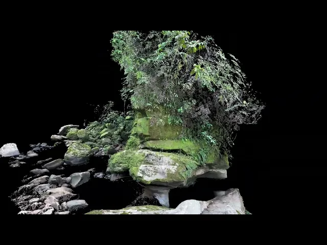
At first, we considered a photogrammetric mesh because it works well on many platforms and devices. But for this project we wanted something that could transmit a stronger sense of presence. 3D Gaussian Splatting allowed us to show light, shadow, and reflections based on the camera position, and to represent the sky and surrounding environment in a very natural way.
So in the end, 3DGS felt like the right choice. It focuses on visual realism more than perfect geometry, and in this case that helped the place look closer to how it feels in real world.
Do you remember when you first came across the technology?
It was a couple of years ago, when I was searching for simpler ways to capture places using more portable gear. The idea of creating a 3D model from almost any camera, and getting such realistic results, immediately caught my attention. I had already been working with reality-capture projects for animation, so this opened a completely new path to experiment with. Back then, working with these models was more complicated and the process was not very user-friendly, but things have improved a lot. Today we have better compression methods and different platforms that automate parts of the workflow.
Were there any moments during processing where you realized the power of seeing the Harakbut Face “come alive” digitally?
One moment that made the project feel truly alive was when we finally merged the drone footage with the 360-degree cameras. Each lens had a different perspective, and we had recorded at different times of the day, with noticeable changes in light. That made the alignment very difficult. We spent several days testing, adjusting positions and color, until everything finally matched. The model appeared complete, with the sky, the water, and part of the mist. In that moment, it felt very close to being there again.
Another moment was seeing the final model running inside the Quest 3 VR experience. At first the file was too heavy, but around that time new compression tools for 3DGS became available. We went from almost 1 GB to about 20 MB while keeping good detail and smooth playback. Experiencing the Harakbut Face in VR, lightweight, immersive, and without losing the atmosphere of the place, made the whole effort worthwhile.
From a documentation standpoint, how does a lifelike 3D model differ from traditional photography or film in preserving this kind of heritage site?
A lifelike 3D model changes the way we document heritage sites because it goes far beyond recording how something looks. The immersive aspect is a major shift. Instead of being limited to a single frame or camera path, you can explore the space from any perspective, walk around objects, study details up close, and understand how elements relate to each other in scale.
That sense of presence is something photography and video cannot reproduce. In a 3D model, you perceive the real proportions of the site and recreate the feeling of standing there. This transforms documentation from a passive image into a spatial record that can be explored, measured, studied, and preserved for future generations.
In your view, what role does immersion play in helping outsiders appreciate the cultural and environmental context of the Harakbut Face?
The Harakbut Face is located above a large sacred river lagoon, deep and completely unique within the surrounding river system. When you stand in front of it, facing the water, the scale of the rock formation and the silence of the lagoon create a physical sense of presence that is difficult to explain with photos or videos. Immersion helps to feel that relationship between landscape, energy, and symbolism. It allows people to sense why this site may have been meaningful for past communities, not only as a geological formation, but as a place with cultural and spiritual importance.
Have you seen examples of the 3D twin being used for education, research, or advocacy yet?
I recently saw an example here in Peru, at Gran Pajáten, where researchers used LiDAR to detect more than one hundred structures hidden in the surrounding forest, and then applied photogrammetry to generate precise 3D reconstructions of the main architecture. That digital record lets them study the site remotely, test restoration ideas, and share the space for educational purposes without putting pressure on a fragile location.
What do you hope that gaussian splatting and other radiance fields will enable in the future?
I hope it continues moving toward dynamic and reactive representations. Recently I have seen advances where splats are no longer completely static, but can move or react, and that opens a new direction. It would be incredible if radiance fields could represent places across different moments in time, instead of a single frozen capture. Imagine seeing lighting change, shadows move, vegetation reacting to wind, or rain interacting with the scene. In the future, this could let us experience how a real location transforms throughout the day, across seasons, or under different environmental conditions. For archaeology, it could even allow an instant transition between the present-day ruins and a possible reconstruction of how the site might have looked.
And beyond documentation, the reactive aspect has huge artistic potential. Artists could design interactive layers, sound-responsive splats, or living installations where color, light, and form respond to viewers or music. In that sense, the radiance field would become both a record of a real place and a creative medium that can evolve, transform, and express new ideas.
If there was any current bottleneck of gaussian splatting that could be fixed immediately, what would the biggest impact be for you?
From my experience, the main challenge has been the processing and rendering of complex models. Even with good hardware, the training times can be very long, and rendering animations can take just as much effort. If that part could become faster and lighter, both on computers and mobile devices, it would make a big difference for projects like this.
It would make capturing and sharing data much easier. Communities with limited resources, including Indigenous groups, could document their own heritage without needing expensive equipment. We would probably start seeing remote places being captured directly by the people who live there.
You can view the final reconstruction through Splatter.


New to Gaussian Splatting? Start here


