

Branches, cables, chain link fences, even the negative space between leaves, all sit precisely where the GIS says they should. Previously it was difficult to visualize these fine details, that can have a big impact on work. However, this historical challenge is getting a big solution thanks to a new layer type that is bringing lifelike 3D to Geospatial teams.
With ArcGIS 3.6, arriving in November 2025, Esri is formalizing the beginning of a transition to lifelike 3D. The company is introducing a Geospatial Gaussian Splat layer that plugs directly into the ArcGIS platform. The new layer is a first class citizen directly within their engine that can overlay with terrain, parcel polygons, BIM layers, or utility networks, then run the same spatial analysis you already rely on.
Gaussian Splats have already earned a reputation in computer graphics for their uncanny ability to capture thin structures and reflective materials. Treating splats as a proper layer inside ArcGIS matters. Analysts can intersect them with zoning envelopes, clip them to easement buffers, or extract attributes from a corridor study without leaving their core workflows. Because the layer is registered to authoritative coordinate systems, every measurement and overlay respects the same geodetic truth that underpins the rest of the enterprise stack.
These layers are produced by the ArcGIS Reality Engine, Esri’s production system for large scale Reality Mapping. The engine is designed for survey-level accuracy, so the splats inherit the same rigor that photogrammetric meshes and point clouds already enjoy in ArcGIS Reality. A long remaining criticism of radiance field representations is their ability to be measured to survey grade levels. This is one of the first implementations that looks to be bringing splats to the same levels.
Another question has been the scalability of gaussian splatting. While NeRFs have been proven to be scalable infinitely, the same holds true for splats. Esri’s implementation is capable of reconstructing entire cities and larger. To work at that scale, the Reality Engine supports distributed processing across multiple GPU-equipped machines. Teams can throw a farm of nodes at a backlog of aerial sorties or street-level captures and end up with one integrated Gaussian Splat layer rather than a patchwork of tiles stitched by hand.
The same mentality shows up on the delivery side. Esri has years of experience streaming massive 3D meshes for whole cities or even nations. The splat layer uses a level of detail hierarchy that partitions the data into a tree of resolutions. Only what is in view, at the resolution the camera needs, is sent to the client. That keeps the interaction smooth on desktop and, once the web renderers ship, makes it practical to explore kilometer scale scenes in a browser without melting a laptop.
There has been considerable excitement across industries about the potential of a universal file format to serve splats. Esri has been participating in these meetings with the Khronos Group and remains an ongoing conversation.
The 3.6 version of ArcGIS with gaussian splatting support will be released in November 2025, with additional rendering on the web for the ArcGIS Scene Viewer and Javascript API will follow in early 2026.
Esri is laying the groundwork for an exciting adoption of radiance field based representations that will be soon making an impact for geospatial and AEC clients around the world. Learn more about Esri’s offerings through their website.


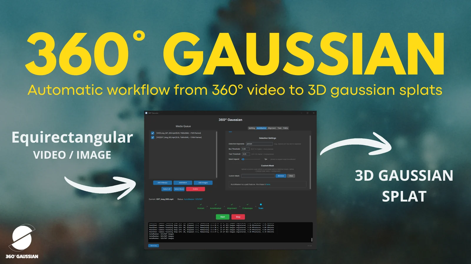

New to Gaussian Splatting? Start here


