Mosaic Releases Prague REALMAP Dataset

Michael Rubloff

Michael Rubloff

Tags

Email
Copy Link
Twitter
Linkedin
Reddit
Whatsapp
Mosaic51 REALMAP

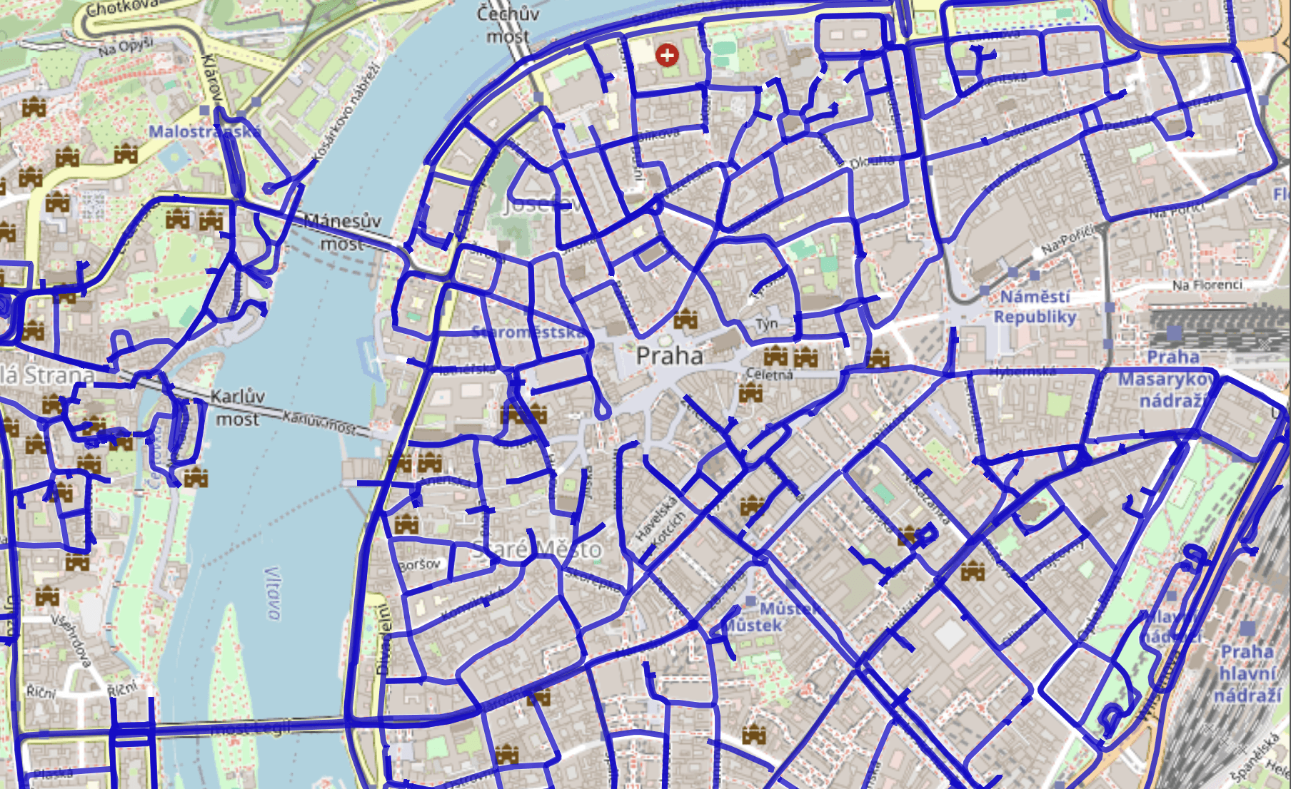
Mosaic has just released something extraordinary, a truly massive open dataset of Prague, freely available for non commercial research and experimentation. The release, called Prague REALMAP, contains over 1.2 million geo-referenced, anonymized images captured at one meter intervals across nearly the entire city center. In total, it amounts to more than 15 terapixels of visual data, making it one of the most detailed urban image datasets ever made public.

The imagery was captured using the company’s Mosaic X camera with a global shutter sensor that produces 91MP imagery, designed for high speed mobile mapping. Each frame consists of six synchronized 12-megapixel images, giving researchers centimeter level precision and consistent coverage under ideal diffuse lighting. That combination of quality and density makes it an incredible foundation for anyone working with radiance field methods like Gaussian Splatting or NeRFs.

The dataset, which spans 118 reels totaling roughly 4.6 TB, can be downloaded directly from Mosaic after signing a CC BY-NC-SA 4.0 license. Each reel comes with calibration data, positional metadata, and full pose information. It’s an especially good fit for those experimenting with large scale scene modeling, since it covers everything from narrow cobblestone streets to broad urban courtyards, all with consistent geometry and exposure.

For the gaussian splatting community, this is a welcome gift. Access to real world datasets of this size and precision is rare, especially for free, and it opens up a wide range of possibilities such as benchmarking Gaussian reconstruction pipelines. Mosaic’s goal in releasing it is to encourage collaboration and fuel research, and it’s easy to see how it could become a new go to dataset for anyone experimenting in the space.

Those interested can find the registration and download form on Mosaic’s REALMAP portal, along with tools for selecting which geographic reels to pull down. It’s a generous move from a company that continues to quietly shape how large scale 3D capture is done.

Featured

Recents

Platforms

Splatware Expands Its Gaussian Splatting Platform with New Training Models and 360° Workflows

Splatware introduces new Gaussian Splatting training models, expanded input support for images, video, 360° media, Insta360, Antigravity A1, COLMAP, and Radiance Field datasets.

Johannes Krüger

Aug 7, 2026

Platforms

Splatware Expands Its Gaussian Splatting Platform with New Training Models and 360° Workflows

Splatware introduces new Gaussian Splatting training models, expanded input support for images, video, 360° media, Insta360, Antigravity A1, COLMAP, and Radiance Field datasets.

Johannes Krüger

Esri Adds Georeferenced Gaussian Splat Layers to the ArcGIS Maps SDK for Unity at 2.4

Esri ArcGIS Maps SDK for Unity 2.4.0 adds a georeferenced Gaussian splat layer type for Unity scenes, on desktop only.

Michael Rubloff

Aug 7, 2026

Esri Adds Georeferenced Gaussian Splat Layers to the ArcGIS Maps SDK for Unity at 2.4

Esri ArcGIS Maps SDK for Unity 2.4.0 adds a georeferenced Gaussian splat layer type for Unity scenes, on desktop only.

Michael Rubloff

Platforms

XGRIDS Adds Real Time Lights and Shadows to Gaussian Splats in LCC Unity SDK 2.2.0

XGRIDS LCC Unity SDK 2.2.0 adds real-time point and spot lights with shadow casting to Gaussian splat scenes, gains Ubuntu support, and improves XR rendering.

Michael Rubloff

Aug 6, 2026

Platforms

XGRIDS Adds Real Time Lights and Shadows to Gaussian Splats in LCC Unity SDK 2.2.0

XGRIDS LCC Unity SDK 2.2.0 adds real-time point and spot lights with shadow casting to Gaussian splat scenes, gains Ubuntu support, and improves XR rendering.

Michael Rubloff

Esri Adds Gaussian Splat Layers to the ArcGIS Maps SDKs for Native Apps at 300.1

Esri ArcGIS Maps SDKs for Native Apps 300.1 adds Gaussian splat layers to .NET and Qt desktop apps, reading web layers or local 3D Tiles for offline use.

Michael Rubloff

Aug 6, 2026

Esri Adds Gaussian Splat Layers to the ArcGIS Maps SDKs for Native Apps at 300.1

Esri ArcGIS Maps SDKs for Native Apps 300.1 adds Gaussian splat layers to .NET and Qt desktop apps, reading web layers or local 3D Tiles for offline use.

Michael Rubloff

Michael Rubloff

Written by Michael Rubloff

Michael is the Founder and Managing Editor of Radiancefields.com

Email
Copy Link
Twitter
Linkedin
Reddit
Whatsapp

More from Michael Rubloff

More from Michael Rubloff

Esri Adds Georeferenced Gaussian Splat Layers to the ArcGIS Maps SDK for Unity at 2.4

Esri ArcGIS Maps SDK for Unity 2.4.0 adds a georeferenced Gaussian splat layer type for Unity scenes, on desktop only.

Michael Rubloff

Aug 7, 2026

Esri Adds Georeferenced Gaussian Splat Layers to the ArcGIS Maps SDK for Unity at 2.4

Michael Rubloff

Aug 7, 2026

Esri Adds Georeferenced Gaussian Splat Layers to the ArcGIS Maps SDK for Unity at 2.4

Esri ArcGIS Maps SDK for Unity 2.4.0 adds a georeferenced Gaussian splat layer type for Unity scenes, on desktop only.

Michael Rubloff

Aug 7, 2026

Platforms

XGRIDS Adds Real Time Lights and Shadows to Gaussian Splats in LCC Unity SDK 2.2.0

XGRIDS LCC Unity SDK 2.2.0 adds real-time point and spot lights with shadow casting to Gaussian splat scenes, gains Ubuntu support, and improves XR rendering.

Michael Rubloff

Aug 6, 2026

XGRIDS

Platforms

XGRIDS Adds Real Time Lights and Shadows to Gaussian Splats in LCC Unity SDK 2.2.0

Michael Rubloff

Aug 6, 2026

XGRIDS

Platforms

XGRIDS Adds Real Time Lights and Shadows to Gaussian Splats in LCC Unity SDK 2.2.0

XGRIDS LCC Unity SDK 2.2.0 adds real-time point and spot lights with shadow casting to Gaussian splat scenes, gains Ubuntu support, and improves XR rendering.

Michael Rubloff

Aug 6, 2026

XGRIDS

Esri Adds Gaussian Splat Layers to the ArcGIS Maps SDKs for Native Apps at 300.1

Esri ArcGIS Maps SDKs for Native Apps 300.1 adds Gaussian splat layers to .NET and Qt desktop apps, reading web layers or local 3D Tiles for offline use.

Michael Rubloff

Aug 6, 2026

Esri

Esri Adds Gaussian Splat Layers to the ArcGIS Maps SDKs for Native Apps at 300.1

Michael Rubloff

Aug 6, 2026

Esri

Esri Adds Gaussian Splat Layers to the ArcGIS Maps SDKs for Native Apps at 300.1

Esri ArcGIS Maps SDKs for Native Apps 300.1 adds Gaussian splat layers to .NET and Qt desktop apps, reading web layers or local 3D Tiles for offline use.

Michael Rubloff

Aug 6, 2026

Esri